Saturday, April 11, 2020

Day of Fasting, Prayer, and No People

President Russel M. Nelson asked everyone in the Church of Jesus Christ of Latter Day Saints and, really, everyone in the world, to fast and pray today, Good Friday, for relief from the Coronavirus and financial recovery. I fasted all day, except for water. I drink water when I fast, because the last time I didn't drink enough water I got dehydrated and had a heart attack. And I prayed. But today I also took a drive to west central Utah.

My destination was Crystal Peak, where Randy and I went a few years ago (I'm going back to places where I remember there being few or no people). I also found in a gems and minerals book that a place to find obsidian is near the Crystal Peak road. So I took my mountain bike and headed to that area first.

The obsidian beds are about 40 miles south of Delta on Hwy 257. I went up a dirt road that goes east from the highway and ended up at what I think is the old Cudahy Mine.

To go to Crystal Peak, continue another 4 miles or so on the highway and take the dirt road that goes west. A sign on the highway says Crystal Peak. So that's easy. It's the Black Rock turnoff, and you will soon pass a big tank that says Black Rock Well. Crystal Peak is about 40 miles on that road. If you go, there are two splits in the road where you need to be careful. At the first split, stay left toward Garrison, NOT toward Crystal Peak Minerals, unless you're interested in buying some potassium phosphate (fertilizer). At the second split, stay right. Do NOT go toward Wah Wah Ranch.

I parked at the first gate going to what I think is the old Cudahy Mine and rode my bike a ways up the dirt road. This is at the top. 

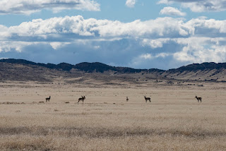
If you look closely at the beginning of this video you can see a pronghorn run across the road from right to left. There were three that crossed in front of me at a good distance. 

This is riding down the road back toward my Sequoia. Watch closely and you'll see me cross a couple of obsidian beds. 

This is obsidian scattered around the hillside. 

There are the rocks I collected. I could only gather what would fit in my jersey pockets. 

Notice one of the pronghorns runs across the road again as I approach the gate near the mine. 


Somehow I ended up across a ravine from my car. Notice the obsidian in my jersey pockets when I open the gate. 

We're now on the west side of Highway 257 heading toward Crystal Peak. I thought this reservoir name was kind of funny in a sad sort of way. What reservoir is so pathetic that it's named for its view of another lake? I drove up a road here a few miles and never found a reservoir, so what you're looking at may actually be the reservoir. 

The saddest part is that the lake that the reservoir views is Sevier Lake, which hasn't had permanent water in it for more than 14,000 years. 

Here's a peek at Crystal Peak. 

This is Crystal Peak. It's mostly rhyolite tuff, which is a light porous volcanic rock made of silica and some other minerals with no iron, which is why it lacks the brown to red colors of the surrounding mountains. When the volcano erupted, the tuff filled into a ravine and hardened into rock. The surrounding earth eventually wore away, leaving Crystal Peak standing here. 


You might think Crystal Peak got its name because it's white against the surrounding mountains, but you'd be wrong. It got its name because it's full of these crystals. They're pretty tiny. 

I drove west from Crystal Peak to Highway 159 and then to Highway 50 and back through Delta. These pronghorns were browsing along the way. They're at least 200 yards away, and still they're ready to run because I stopped to take a picture. 

Due to the coronavirus, Governor Gary Hebert declared that beginning today, April 10, everyone entering the state by air or via most highways such as I-15, I-80, I-84, and US 89 have to register and confirm they are not carrying the virus into the state. Highway 50, "The Loneliest Road in American," is not on the list, and this car from California is sneaking in. I actually passed a car from Washington on Hwy 159. I stopped at the turn to Hwy 50/6 to take his picture, but he turned back toward Nevada, and this car from California zoomed by. I tried to catch up, just for a photo, but even going 80 MPH (not that I went that fast in this 65 MPH zone) wouldn't have been fast enough to catch up to him. 

Thursday, April 2, 2020

Pony Express Trail and Fish Springs


The Pony Express Trail cuts off to the left (south) from Hwy 73 (Eagle Mountain road) just after Fivemile Pass (very popular ATV area). The sign says Faust. The road is dirt most of the way to Faust, about 10 miles. 

Just after Faust, which is really just two houses and a railroad crossing, turn left on Hwy 36 (comes south out of Tooele), drive a couple blocks, and turn right at the Pony Express Trail sign. 

This and the next sign are at the turnoff. 


I'm not sure what the deal is with this compound, but it's a collection of some very nice homes on. gated road in the middle of nowhere, just off the Pony Express Trail road.

This is the Simpson Springs Pony Express stop. There's an outhouse and campground here. The building is a recreation of the original stop. Stones from the original building are in a protected area across the road as part of a cabin that a pioneer built for his wife. Unfortunately, she died during childbirth and never lived in the cabin. 

This is what the Pony Express Trail road looks like for most of it's 90 or so miles. 

And this is what it looks like from ground level. 

Just past Simpson Springs, we met up with this herd of wild horses grazing beside the road. They're part of the 450-horse Onaqui herd of mustangs and are almost always present around this area. 

I tried to take an overhead shot, but they were not crazy about the drone, so I brought it down before they ran away. 

They weren't too shy with two or three cars of people stopping to gaze at them. 

This foal is nursing. There were at least two foals. One was lying down, and we worried he might be dead, but he jumped up when I turned the drone on. 

There were a handful of horses grazing by themselves. 

Drive about 45 miles west of Simpson Springs and you arrive at Fish Springs. Here's Chieko with the Fish Springs points in the background.

Here are the springs. The birds are in the water on the right. I'm not sure what the blue/turquoise water on the left is. It's pretty, but I don't think it's conducive to birds and plants. 

The ponds have a lot of coots and ducks. These pelicans were the only large waterfowl we saw. We did see a couple of hawks, and, of course, crows.

The pelicans flew off when I tried to get a little closer, and they were then joined by what I think is a heron, and a bunch of seagulls. 

These ducks (or maybe coots) took off when I drove past. The water is ripply, because it's starting to get windy. Driving home on I-80, we hit some pretty heavy rain near Grantsville, and I understand from the news that it may turn to snow overnight.

I'm quite sure this cow, and a couple others nearby, are pregnant. A few young calves are already wandering around. 

These are the remains of a Pony Express stop near Gold Hill. After we stopped here, we drove through Gold Hill, where the remains of two houses that burned to the ground in a brush fire are still prominent right in the center of the town. Gold Hill is a partially occupied ghost town. At the main intersection, the only intersection, actually, we weren't sure which way to go to get to Wendover, until we found a faded, tattered, hand-written sign that said, "<-- --="" 55="" miles.="" p="" wendover="">

Wendover was also a veritable ghost town. With all the casinos closed, almost no people people or cars are in town. We stopped at the Pilot Station, which has always been hopping with people when we've been here before, but only one other customer was in the store this time. Even the parking lots to the casinos had cement and other barricades across them.