
Paul Bunyon's Woodpile is not easy to find, because someone removed all the highway markers for this interesting stop. It's near the Little Sahara Sand Dunes. You go up a 3-mile dirt road, and then a 1-mile hike that gets a bit steep at the end, especially if you lose the trail and go straight up the mountain.

These "logs" were formed when a lava flow cooled into 1-foot-by-15-foot columns on the edge of a caldera. A fault then tilted the column masses on their sides.

I'm guessing by this gate at the trail head that the forest service doesn't want motorcycles, horses, bicycles, or large people on the trail.

And the trail isn't well maintained this time of year.

I think this is water cress springing out, but thanks to giardia, it's not safe to eat.

Several of these little guys were climbing around. Based on where I saw this one, I'm guessing it's a cow dung spider. I have no idea how the cows and sheep wandering around got through the entrance gate.

Three log piles sit on the side of this mountain. These formations are rare in Utah.

The ends of the logs.

The logs aren't really round. They have three to six flat sides.

I thought it would be cool to get a picture with a log standing up next to me. It turns out they're heavier than they look. This one wouldn't budge.

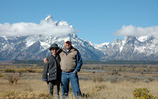
This is a view of the valley from midway down the trail. The steam column on the right is the Intermountain Power Project (IPP) west of Delta. To the right of that is the edge of the sand dunes.
I know you were going to ask whether your car can get up the road. During the summer I think the road's in good shape, but I wouldn't have made it in early March without four-wheel drive. I then spent $12.04 at the car wash to get all the mud off. Driving here is like driving the little cars at Disneyland: You can turn the wheel any direction you want; the car is going to follow the ruts regardless.

There's other stuff to see out this way.

This guy wanted to be sure I got a picture of his "good side." The horn on the other side was broken off, probably still sticking in the last person who took his picture.

Quite a few old mines dot the mountains. And quite a few mines are still active, especially near Eureka and Silver City.

An old concrete grain silo.

The last time I drove on the road that cuts across from the Pony Express marker near Faust to the highway that goes along the north end of Cedar Valley, the road was dirt and we ran over some rabbits (not intentionally). Now the road is paved. This train (same as the one at the top of this blog, if you can see it) was waiting at a red light, I think for another train to pass.

This old gravel pit is the only landmark on the Faust road.

I suppose you could climb up the water tower to see what's inside, or you could just look through one of the many holes in the bottom. It's pretty much just a crow condo.

That's about the end of that day.
4 comments:
Where did you hear about this place to know to go to it?
I went there several years ago, when there were signs on the highway. It's also on a regional map of Utah that I've had for a long time.
That place looks awesome.. I want to go to Paul Bunyon's firewood stack, or whatever it was called. except I do not want to see those spiders. Is that really close up or are they THAT big... like as big as my hand????
Small spiders, maybe the size of a nickel.
Post a Comment