Okay, follow closely. John wrecked his car earlier this summer, so I drove our Corolla to Dallas to let John use it until his family was ready to go to Boston this fall. I think it was in June that John, Mialisa, and the kids drove up here in their van. John then flew home, while his family stayed here for the summer. Mialisa and Wells then flew back to Dallas on August 24, and I volunteered to drive the van and kids to Dallas the weekend.
On Saturday, August 24, we left the Salt Lake Valley at 7 a.m. Randy also went with me, as I decided to make a return road trip out of this and see parts of the country I'd never seen.
 Caroline, Elliot, and Mei watched movies, tickled each other, and slept the entire trip from Salt Lake to Dallas.
  We made only bathroom, gas, food, and sleeping stops. Plus two very quick sightseeing stops. This one is at Wilson Arch. Caroline had remembered this from when John and I drove from Dallas to Salt Lake with the kids in March this year, and she asked if we could stop here again.
  Elliot wrote his name in the sand next to the parking area. I told him that the T and i were upside down, but he said that he wanted people to be able to read his name from the road.
  I wished I had a time-lapse camera when we stopped at the Motel 6 in Tucumcari, New Mexico. The three kids slept in one bed. I woke up about 1:30 and found Mei sitting on the floor against the bed asleep. Caroline was spread across 2/3 of the bed with her leg hanging off. I don't think Elliot moved all night. Anyway, at my 1:30 wakeup, I went to the bathroom, and when I came back, everyone was back on the bed, still asleep.
  This is the famous Cadillac monument that a farmer planted near Amarillo, Texas.
  The cars have been heavily graffitied. And the paint cans are all around.
  Caroline blends well into this one.
  This is us.
  Elliot tried his hand at graffiti.
 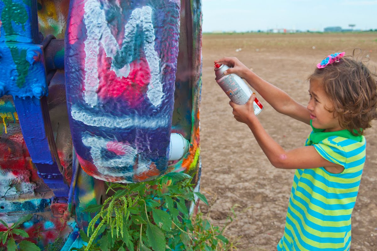 So did Mei. Caroline did, too. And I may have written my name somewhere.
  John's family at their almost-empty Dallas home.
  This is about as close as Wells would let me get to him.
  We went to Wild About Harry's (that's Harry in the front) for ice cream.
  The next stop on Monday was Oklahoma City, to see the Austins and their new house.
  I think this is a study or entertainment room.
  Caleb's bedroom.
  Kali and Emi's room.
  Kitchen.
  Kali's now in middle school. They grow up too fast, especially when they're so far away.
  Three kids.
  The family.
  A Texas longhorn near Pops.
  A rare round barn. This is in Acadia, which is where Pops and the Texas longhorn are.
  Pops. This place has 500 flavors of soda pop.
  We went to Pops with Jamie and the kids. Then when Randy and I headed toward Kansas, we discovered that our connection to I-35 was right near Pops, so we stopped again and had chicken-fried steak for dinner.
  We stayed in Wichita Monday night and visited the Coleman (camp equipment) factory and factory store on Tuesday.
  And we ate lunch at an old gas station and garage called the Pump House.
  This is inside the Pump House.
  This is Kansas.
  This is also Kansas.
  This is sorghum. We saw this growing everywhere and thought it looked like short corn stalks, but it clearly wasn't corn. We wondered for some time what it could be. I did remember that sorghum is a major U.S cash crop that is mostly exported to third-world countries. It is a hardy plant that grows well in arid places. I guessed that this must be sorghum, but I really had no idea what sorghum looked like until I looked it up on Google later in the evening.
  In the middle of nowhere Kansas is this Swedish town called Lindsborg, which has these uniquely painted Dalas on many street corners.
  Also in Kansas is Rock City, which is an outcrop of sandstone concretions. This is not really a city, but a little park a few miles outside Minneapolis, KS. I have no idea how these rocks were formed, but they remind me of very large versions of the Moqui Marbles we collected in Southern Utah several years ago. By very large I mean the biggest Moqui Marbles are probably three inches in diameter, while some of these Rock City formations are 20 feet in diameter.
  Rock City up close.
  Outside another little town called Lebanon on the northern edge of Kansas is the center of the lower 48 United States. If the 48 states were a flat plane, this is the spot where they would balance if placed on a sharp point.
  And here I am in perfect balance.
  This tiny little church sits on the Center of the U.S. park property.
  It's a real church with one-person pews, a pulpit, and a donation box.
  This road leads from the Center back to Lebanon, which itself is a bit out of the way to anywhere.
  The sun set on Kansas shortly after we left the Center of the U.S.
 I didn't know that Nebraska was the home of Arbor Day. First, I had never heard of Arbor Day until I went to work for the government (Utah County) and found out it was a government holiday, until citizens complained and it was replaced by a floating holiday. Second, I thought Arbor Day was when we're supposed to plant trees, and I'm not sure Nebraska has any trees.
  This is Nebraska. Notice the windmill spinning. There is nothing here to stop the wind. I think if someone sneezes in Canada, the windmill here turns. When we got to Kadoka, South Dakota, I asked the lady at the hotel if it was always so windy. She said, "This isn't wind. This is a breeze. Tomorrow it's supposed to be windy." And it was.
  I've often complained that our chapel is way too small. But after seeing this one in Valentine Nebraska, I suppose I can't complain. We couldn't go inside, but I'm thinking it has a chapel, one classroom, and bishop's office. The foyer was about six feet by six feet and led to three solid doors.
  This is an original Pony Express stop in a park in Gothenburg, Nebraska. I thought it was interesting, because I've spent quite a bit of time on the portion of the Pony Express trail that runs through Utah's West Desert, and it just felt like this made a connection.
  South Dakota. This is a recreated western town called 1880s Town. Definitely a tourist trap, but one that is well done and worth the stop.
  This church atop the hill is next to the 1880s Town. I think it's a currently functioning church. There is another church in town that is just for show, although it too was a functioning church at one time.
  Looking down the street of the 1880s Town.
  A gas lantern hanging over the boardwalk.
  And a view of the town through the lantern. South Dakota's Black Hills experienced a gold rush in the 1870s, and by 1880 the Black Hills were well populated with towns like this.
  This is a typical prairie homestead in the late 1880s and early 1900s.
  Small windmills are plentiful throughout Kansas and Nebraska. We guessed that they bring water up from wells for the abundant cattle.
  A street sign in the 1880s Town. The town was born when a movie company started building a main-street set for a western. But winter set in, the movie company moved out, and it donated the set to the landowner. He then began collecting authentic buildings and other memorabilia from around the area and locating it here.
  Here I am pulling up in my carriage.
  The museum has a lot of the props from the movie "Dances with Wolves," which starred Kevin Costner.
  Here I am feeding Otis, the resident camel.
  Otis is quite the ham.
  And here I am taking Lulu for a walk.
  Our next stop was the Minuteman Missile National Historic Site. The United States used to have thousands of nuclear missiles aimed at sites all over the former Soviet Union. Of course, the USSR also had missiles aimed at us. The idea was that because we could annihilate each other, neither side would fire first. And the strategy seems to have worked.
  We visited a control center, which controlled 10 missile silos spread over several miles. The actual control center is inside a reinforced pod 30 feet underground and suspended for shock absorption in case of an incoming nuclear missile. The controllers even had to wear seatbelts.
 The United States had two missiles aimed at each Soviet target. From launch in the United States to detonation in the Soviet Union took less than 30 minutes, and the first missile would be followed by a second as a backup. Thus this pizza-box artwork that says: "Worldwide delivery in 30 minutes or less, or the next one is free."
 This is the edge of the door to the control capsule. The edge is the entire section that you can see. The front and back surfaces of the door do not show in this picture. I forgot how many tons it weighs.
  This is the control center, which was manned by two people in 24-hour shifts. This man is now conducting tours, but he was also one of the controllers when this site was active. He is also the only person ever to fire a Minuteman Missile. He fired a test missile.
 This pod has an escape hatch, which is basically a trap door that leads to a tube to the surface. The tube was filled with sand for bomb protection, and when the door was opened the sand would pour out. The reason for the escape hatch was because if a missile hit near here, no one above would be alive to let the two controllers out, and the elevator shaft would likely be full of rubble.
 This is the door covering the missile at one of the silo sites. This door weighs several tons and is pulled back and forth over the missile on a track. The silo sites had no people stationed at them. They were completely controlled by the control center, or an airplane if the control center were destroyed. Each control center managed 10 missiles, and each squadron had five control centers that were interconnected, so each control center could potentially launch 50 missiles. Several hundred missiles were scattered across South Dakota, with more in North Dakota, Montana, Nebraska and other remote plains locations.
  This is a missile in its silo (not an active missile, of course). Because it's open to the public, it's covered with a plastic window, which is reflecting the sky.
  Next are the Badlands.
  Good reason to view the Badlands from the car.
  The Badlands are weather-carved formations similar to Canyonlands in Utah but from a different strata. The Badlands look more like dirt than rock.
  They are quite interesting, but not a place I'd like to be lost or even camp overnight.
  There is wildlife here. This is a female desert bighorn sheep.
  And this prairie dog town is pretty large.
  With a mess of residents.
  A trip through South Dakota wouldn't be complete without a stop at Wall Drug. This place started as a small drug store in 1931 that offered free ice water to travelers. That proved popular in the days before air-conditioned cars, and soon this was a major tourist trap. Wall Drug today is maze of gift shops, cafeterias, and a small drug store.
  Inside Wall Drug.
  Our main focus in South Dakota was Mount Rushmore. We couldn't actually find the mountain, but we did find this Coke machine with a cool picture of Mount Rushmore.
  Just kidding. We visited Mount Rushmore in the evening, when the ranger showed a 30-minute video that explained why Washington, Jefferson, Roosevelt, and Lincoln were chosen as the subjects of the granite carvings. Then he invited all military veterans to come on the stage to be honored. While they were on the stage, we sang the Star Spangled Banner. The lights then came on to illuminate the statues.
  We came back the next morning to take some sunrise pictures. These presidents face southeast, so sunrise pictures are better than sunset pictures.
  The sculptor of these faces was Gutzon Borglun, who also carved the relief on Stone Mountain in Atlanta, Georgia. He was born in St. Charles, Idaho, to Mormon immigrants from Denmark.
  I like this view of Washington from a turnout in the highway.
  In 1939 Chief Henry Standing Bear sent a letter to Polish American sculptor Korczak Zioklowski saying "My fellow chiefs and I would like the white man to know that the red man has great heroes, too," and requested him to make a carving of Crazy Horse. This project accepts no government funds and thus is progressing very slowly. It won't be finished in my lifetime.
 Eventually, it will look like the small brass statue in the foreground. The theme for this carving comes from a saying attributed to Crazy Horse: "My lands are where my dead lie buried."
 We also took a tour through Jewel Cave in the Black Hills. The formations in this cave are almost all calcium carbonate.
 The calcium carbonate is thick on all the walls, except where it has broken off.
  We found a really neat place in Hot Springs, South Dakota. This small area was probably a sinkhole when 20,000-pound mammoths and smaller wooly mammoths roamed the area 26,000 years ago, along with giant bears, horses, camels, and other animals. The mammoths (and a few others) fell into this sinkhole and died. Eventually the sinkhole filled with mammoths and dirt and was compressed ("by these 20,000-pound mammoths rolling around on top of the sinkhole"), making it harder than the ground around it. The surrounding softer ground washed away and left this hill. A housing developer discovered the mammoth bones and turned the site over to science. These are actual bones, not fossils, but the DNA has been washed away, so the scientists can't make any connections with any living species.
  This is one heavy bone.
  All those bones made me hungry for Fred Flintstone food, so we stopped and got BBQ from this guy and his two boys selling it from the back of his truck in a parking lot in Hot Springs.
  This was really quite tasty.
  In Wyoming we drove up to Devil's Tower.
  This rock mountain was formed from volcanic magma that cooled in columns with eight or more sides. I think this is similar to the rock formations at Paul Bunyan's Wood Pile near Delta, Utah, but those rocks are on their sides. The mountain is essentially a mass of these pillars or columns.
 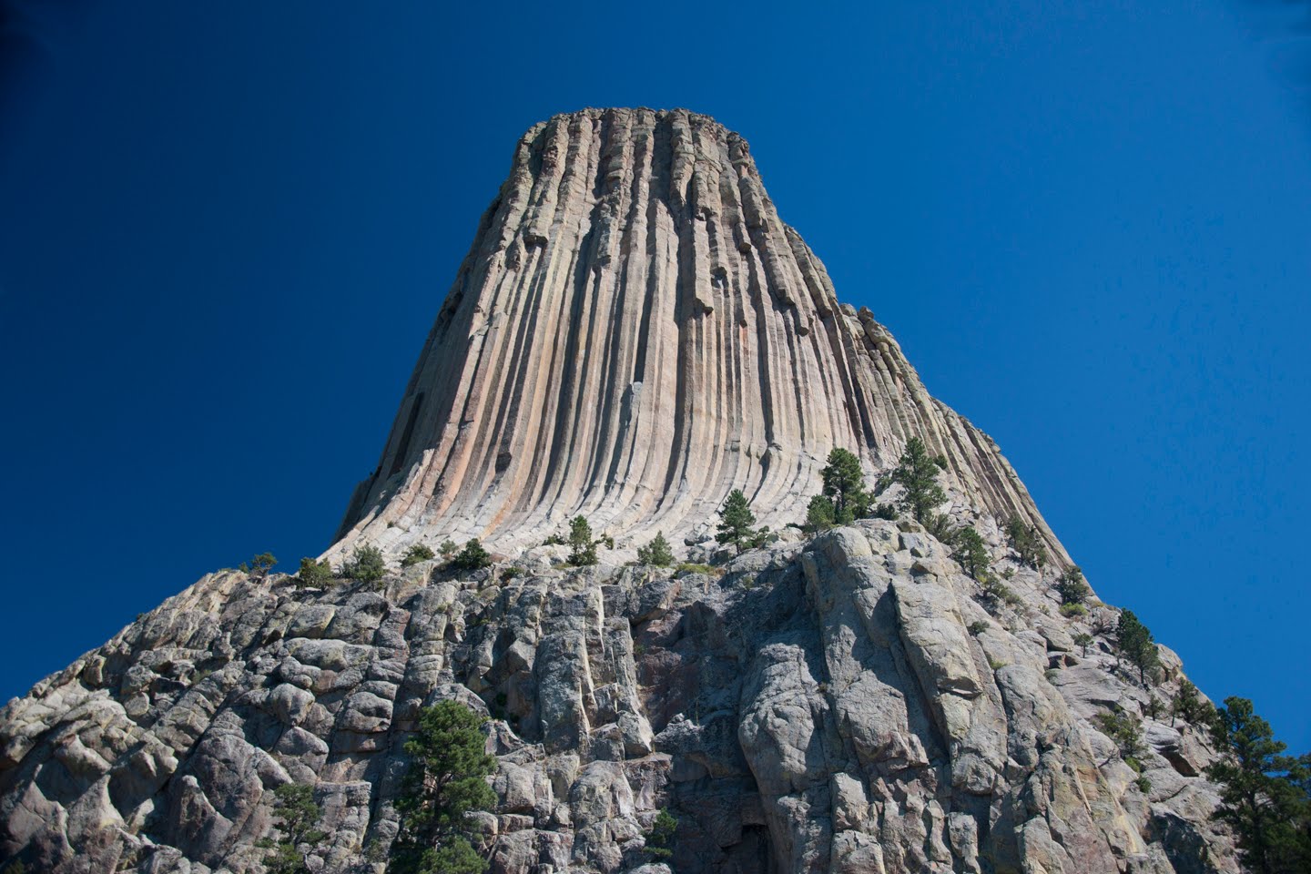 We walked around the tower on a 1.5-mile trail.
  This is a very popular place for rock climbers, and the size of the climbers in this picture shows the size of the mountain. It takes good climbers about four hours up and four hours down. The record is by a free climber who scrambled up in 18 minutes. He died in fall in Yosemite a few years ago.
  We happened to be here just as the moon was setting on the tower and some hawks were circling around.
  Native Americans (and Native American wannabes, I suppose) leave these prayer symbols around the tower.
  Further south in Wyoming is Martin's Cove, where the Willie and Martin Mormon handcart companies were bogged down in the snow while on their trek to Utah in 1856. The church hosts multiday treks here for the youth during the summer. Anyone can stop here anytime and pull a handcart out to Martin's Cove, about 2.5 miles from the visitor center (five miles round trip).
  The church provides handcarts that are actually a lot heavier than the ones the pioneers used. Theirs were about 75 pounds, and many didn't have sides. The carts used on today's youth treks are 120 or so pounds.
  We saw several cottontails hanging around the visitor center. Guns are not allowed here.
  Near Martin's Cove is Independence Rock. This is a granite rock that 500,000 pioneers passed as they headed to Utah, California, and Oregon. About 70,00 of the pioneers were Mormons heading to Utah. The pioneers left Missouri in the spring and tried to reach this rock by July 4, Independence Day.
  Many pioneers scratched their names into Independence Rock, mostly on top of this very windy outcrop.
3 comments:
What a fun trip. I went to Devil's Tower and Mt. Rushmore and surrounding areas on a month long trip just before high school started. It was a blast. I hope to take our kids to some of these places when they're a bit older.
Wow, Dad. Misa and I kept saying what a wonderful dad you are to volunteer to drive all the way to Dallas through all of these boring states, claiming to want to see all of these interesting places and things. I've driven between SLC and Dallas many times now, and the only places I thought were remotely interesting were I70 through the ski towns west of Denver, Moab, and the Arches. Guess I should pay a little more attention next time! Can't wait to read about your next trip. Thanks again for all your help!!!
That was a looong road trip. Looks like we did the same things in S Dakota. We just got our new couches and I don't like looking at that picture of our front room, it looks so bare!
Post a Comment