Chieko went to Boston to visit John's family and to go to Harvard. So I was stuck with figuring out what to do as a bachelor for a week. The answer was to ask for advice on FaceBook. I got three suggestions: ice cream, copious amounts of pizza, and a road trip.
I was thinking I'd like to go camping near Mirror Lake on Friday night. But I had a problem with work. I had a project that I needed to finish by Monday. The problem was that it looked like I wouldn't get the information I needed to finish the project until later in the week, meaning I'd end up working over the weekend. And I had no work in the middle of the week.
So, on Tuesday, I decided the answer was a road trip. Leaving that day. The home teachers were coming at 7 p.m., so I left here about 8 p.m. I got to about 106th South when I remembered that I hadn't done my estimated quarterly taxes, which were due on Wednesday. So I turned around and did my taxes. Don't ask how I figured my taxes and mailed them off in 20 minutes. I just did.

I did have a plan. I've been reading a book called "Blood and Thunder." It's basically about Kit Carson, but discusses the Navajos extensively, since Kit Carson was an important instrument in driving them out of their homeland and onto a reservation. Their last stronghold was Canyon de Chelly (pronounced shay--it's a Spanish version of a Navajo word that means rock canyon) in Arizona, and I wanted to go there. I made it to Green River about midnight Tuesday night. I woke up at 5 a.m. on Wednesday and was on the road at 5:15. I got ready so fast because I had forgotten to bring a toothbrush and deodorant. Just a shower.
 Just some interesting roadside graffiti. When does graffiti become art?
 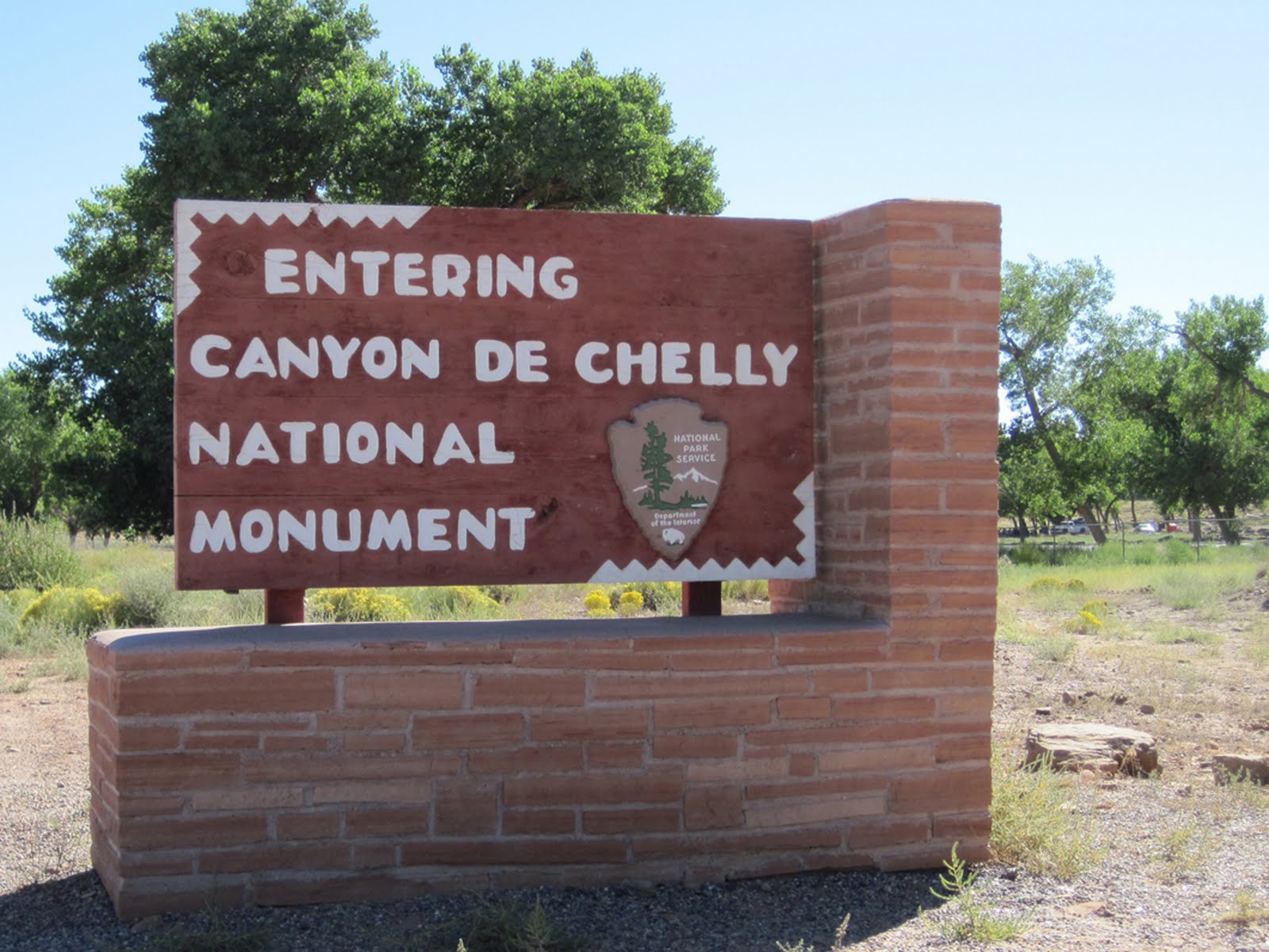 Canyon de Chelly begins at a town called Chinle (pronounced chinlee), which is also the name of the geologic formation in this area and around the Petrified Forest National Park farther south.
  The visitor center at Canyon de Chelly, and the whole Navajo Nation, had its flags at half staff to honor Allen Dale June, who was one of the original WWII Navajo code talkers. He had hitchhiked to Fort Defiance, lied about his age, and ended up helping create the code that baffled the Japanese. His funeral was the same day I was at Canyon de Chelly (Sep 15) at and LDS stake center in Page, Arizona.
  This is Canyon de Chelly. There are actually three canyons that merge together--Canyon del Muerto, Black Rock Canyon, and Canyon de Chelly, plus a couple of side canyons. The Navajos (they called themselves Dineh, meaning The People) used this canyon as a refuge and hideout when they were threatened by other Indian tribes or the white guys. They grew peach trees, corn, and other produce in the bottom of the canyon.
 Before the Navajos, the Pueblos and their ancestors, the Anasazi also lived here. The center of this structure has construction that matches that of the dwellings in Mesa Verde with less skillfully built structures on either side. The Navajos avoided using these previously inhabited buildings.
  At each viewpoint and trail are Navajo vendors selling pottery, jewelry, and dolls.
  I bought a little vase from Audrey Joey. She and her husband made each of these pieces.
  The Navajos believed that Spider Woman, a goddess, taught the women how to weave and also played humorous jokes on The People. She lived at the top of what is now called Spider Rock.
  If you look just past the shrubs in the foreground you can see a small alcove in the cliff on the left. When the U.S. Army was searching through the canyon--no white man had ever been in the canyon, and the Navajos believed they never could enter--a group of women, children, and old people hid in this alcove while the men were out hunting.
As the soldiers passed on the canyon floor, one Navajo woman went crazy and started screaming at them. A soldier climbed up the canyon wall, and as he reached the alcove another Navajo woman charged him and together then fell to their deaths at the bottom of the canyon. The soldiers then began firing into the alcove until their ricocheting bullets had killed everyone.
The Navajos call this The Place Where Two Fell Off. The sign at the viewpoint calls it Massacre Cave.
 This rock island is called Fortress Rock. The Navajos, and the Pueblos and Anasazi, cut footholds in the rock and used poles with notches to climb to the top. They would then pull up the poles to protect themselves from enemies.
This is what they did when Kit Carson's soldiers came to drive them out. (Kit Carson never entered the canyon, perhaps because he was superstitious about white men not being able to enter the canyon.) Kit Carson had already destroyed all the Navajos' corn and other crops outside the canyon, and his soldiers finished the job by cutting down all their cherished peach trees and other crops on the canyon floor. Eventually, the Navajos on Fortress Rock ran out of water and began starving, and thousands surrendered to the U.S. Army. They were then marched in The Long Walk, where many died, to an oasis in New Mexico called Bosque Redondo, which was a terrible place with alkaline water that made everyone sick. The Navajos' planted corn, but it was devastated by worms and hail, and many starved to death.
 A friendly lady runs this hogan that has a soft sand floor and has walls lined with her pottery and other artwork for sale. She also sells really good fry bread.
  This is the patio where, after I brushed about 1/4-inch of sand from a chair, I enjoyed my fry bread and soda.
  Powdered sugar, cinnamon, and honey on bubbly hot fry bread.
  This little guy really likes fry bread, too.
  I always thought the roads in Utah were bad, but I traveled a bunch of Arizona's two-lane highways to get to Canyon de Chelly, and some of them made Utah's roads look like airport runways. This one had these cracks about every 20 feet. I was in the Z3, which has a pretty stiff suspension. The dollar bill shows how wide the cracks are, and it is a metaphor for what was happening to my tires, suspension, and teeth.
  I would not want to drive here during a thundershower.
  This mud had been scraped off the road. I'm not sure, but this car looks like it got covered in the last mud flood and then was scraped up with the rest of the mud off the road. I hope the driver got out first.
  In the middle of nowhere (which is pretty much everywhere) was a revival.
  I think these tents were the location of the revival. I was breathing okay, and my heart was beating, so I didn't feel that I needed any reviving at the time and didn't stop.
  I had visited Canyon de Chelly, which was my goal, but I've also always wanted to visit Petrified Forest National Park, which is just a couple hours from Canyon de Chelly. So I drove to and stayed in Holbrook, about a half hour from the National Park. And I ate at Bubba's Big Pig BBQ. The sundown light makes this look a lot nicer in the photo than it looks in real life. I wouldn't have stopped, but there were several other cars here. It looked like an old laundromat in a rundown section of town.
  This is Bubba (or Jim). As far as I could tell, he was running a one-man show, owning the restaurant, cooking, and waiting tables.
  I ordered the three ribs for $10.95, but some guys just before me had bought the ribs out. So I had brisket. It was quite tasty and worth the stop.
  The next morning I arrived at Petrified Forest National Park.
 The south entrance has the great majority of the petrified wood. This is very fascinating.
  These trees were swept away by a wild river, probably during storms, when all the land on the earth was one mass during the Triassic Period and Arizona was where today's Panama is (before the first Jurassic Park).
  It's amazing that after 200 million years, many of these trees are still relatively intact. They've broken into pieces under their own weight, but they are still in alignment. And instead of being encased in rock, they're in sand.
  The trees were encased in silica from nearby volcanic ash, which preserved them and slowly replaced the wood fibers, turning the trees into quartz. The colors come from other minerals and metals such as iron (red or orange) and manganese (purple).
  The detail is amazing.
  When this area was first discovered, many people broke these open, using dynamite at times, to get to the amethyst and other semiprecious stones. There was even a mill built nearby to grind the trees into abrasives for things like sandpaper, but it never went into operation. The people from Holbrook protested the destruction of the petrified trees, and eventually Theodore Roosevelt declared this a National Monument in 1906.
  I took the little walk around the visitor center and did a three-mile round-trip hike on the Long Log and Agate House trails. I'm glad I took water.
  Wouldn't this be a great piece in your garden?
  The Park Service is vigilant at keeping people from removing even the smallest pieces. Warnings are everywhere that the minimum fine is $325, plus possible jail time, when you can buy petrified wood in stores from $2 and up (well, maybe $20 and up). There is also an inspection station at the park exits. Even so, the park loses 12,000 tons of petrified wood every year.
  This is so cool. But I would not come here during the summer. Even on September 16, the weather was hot, and the only trees in this forest are 200 million years old and lying on or under the ground.
 None of the trees appears to have branches. Scientists assume those were knocked off as the trees flowed down a whitewater river. They then piled up when they hit a flood plane, which is what this area was.
  Some Pueblos built a house out of the petrified wood. It was restored in the 1930s but not in accordance with current Park regulations or thinking.
  The north end of the Park is like a separate park. This is an homage to Route 66, which I'd like to drive some day when I have a couple weeks.
  This rock is covered in petroglyphs. Thus the name: Newspaper Rock. There's also a Newspaper Rock in southeastern Utah.
  This is the Painted Desert at the north end of the Park.
  The park also has interesting flora.
  You can buy petrified wood outside the park at one of these fine shops.
  Everything in this rock shop was half price, but the starting prices seemed to be more than double what I had seen in a little more civilized store in Holbrook.
  This is the store in Holbrook where I shopped. To the right is a large area full of petrified logs. It reminded me of a good-size lumberyard. I bought a piece of polished Woodworthia Arizonica, which I now read is a pretty rare piece. It's mostly black and light brown, not the brilliant colors of the more common Schilderia Adamanica. I like it because it shows the tree rings.
  This cove is at Rock Point, Arizona, which is where I plan to build my hideout.
3 comments:
Wow you saw lots of interesting things. We want to go visit some Native American areas here, maybe over Fall break. I found out that around here they are not called Navajo Tacos, they are just Indian Tacos. I don't think there are any Navajo Indians around these parts. I also learned from Jillian on the Biggest Loser that the Native Americans didn't start making the fattening fried bread until the white people introduced it to them.
The only thing that could have made that trip better would have been some ice cream.
I don't think you're supposed to tell people where your secret hideout is. But I'm glad you did so we now know where to look when you disappear.
Post a Comment